


A series of almost daily storms in recent weeks have dumped heavy rains across Central and Eastern Kentucky, causing many small streams, rivers and some lakes to rise far above normal mid-summer levels.
Waterways in the Golden Triangle, between Louisville, Lexington and Northern Kentucky are very high, with some localize flooding.
With the ground saturated, heavy downpours just runoff into waterways, prompting flash flood warnings, as stream levels rise rapidly, covering roadways, fields and woodlands at the water’s edge.
High water creates dangerous conditions for anglers and recreational boaters. The best advice is to stay away until levels recede.
At this time, many streams and rivers in the region are unfishable, bank full with high, muddy water. Rivers and some lakes are full of drift, which become navigation hazards to jet skis and other small watercrafts.
Discharge rates in tailwaters are very high as lake levels rise and more water in lakes must be dumped. Heavy currents make wading while fishing impossible to very risky.
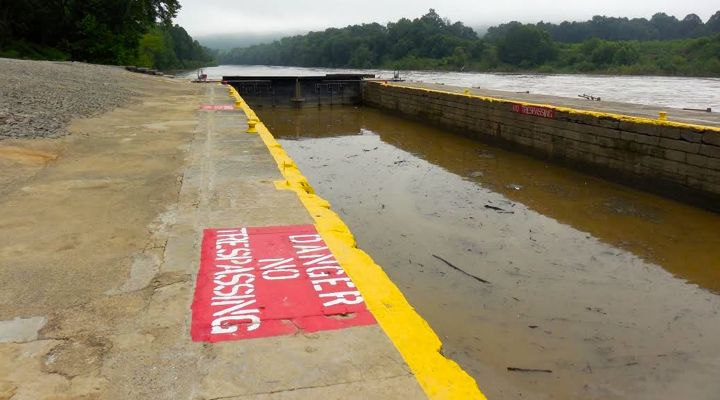
In streams there are several dangers to small boaters during high water, including entrapment in flooded trees and root wads. But the most dangerous situation to anglers and recreational boaters occurs when high water spills over low dams, creating so-called “keeper hydraulics.”
In free-flowing streams, a hydraulic is formed when water falls over a ledge, rock, or log. When the water pours over these objects, it picks up speed and rolls back on itself, creating what paddlers call a “hole.”
Hydraulics are easily identified on a river by the white, foamy water that can be found just below the structure.
At high water the current can become so powerful that a canoe, kayak, or person who falls into a hydraulic, can become trapped in the hole’s circular current.
Life-threatening conditions occur below concrete dams because they form “perfect” hydraulics not usually found on a natural river. The clean, straight lines of a concrete dam allow water to spill over in a perfect wave, and this creates a very powerful hydraulic that can suck a boat or paddler underwater.
Here’s some details about water conditions at local streams:
* The Kentucky River at Lock 2 in Henry County, at Lockport, Ky. was at 18,700 cubic feet per second on Monday morning, July 13 at 9:30 EDT. The 38-year average discharge for July 13 is 2,580 cfs.
* The Licking River at McKinneysburg, Ky. in Pendleton County was at 11,400 cfs on Monday morning, July 13 at 9:45 EDT. The river level has risen seven feet since July 6. The 35-year average discharge for July 13 is 1,200 cfs.
* The Cumberland River at Burkesville, Ky. in Cumberland County is influenced by daily discharges from Lake Cumberland, creating an ebb and flow. The daily low level has risen four feet since July 6. The area has received about three inches of rain since July 8.
* Elkhorn Creek near Frankfort, Ky. in Franklin County was at 3,260 cfs on Monday morning, July 13 at 10:15 EDT. The river level has risen three feet since July 10. The 75-year average discharge for July 13 is 190 cfs.
For detailed information on water conditions on Elkhorn Creek call Canoe Kentucky at (502) 227-4492.
For current water levels and cfs discharges consult the USGS Current Water Data for Kentucky website, which includes 210 reporting stations, organized by county, click here.
Be safe. Stay away from high water.

Art Lander Jr. is outdoors editor for KyForward. He is a native Kentuckian, a graduate of Western Kentucky University and a life-long hunter, angler, gardener and nature enthusiast. He has worked as a newspaper columnist, magazine journalist and author and is a former staff writer for Kentucky Afield Magazine, editor of the annual Kentucky Hunting & Trapping Guide and Kentucky Spring Hunting Guide, and co-writer of the Kentucky Afield Outdoors newspaper column.