


By Tom Latek
Kentucky Today
Earlier this month Eastern Kentucky suffered flooding due to heavy rain and now the central and western parts of the state are on the radar over the next week.
Joe Sullivan, a forecaster with the National Weather Service in Louisville, said much of the problem is not being able to dry out after the repeated bouts of rain.
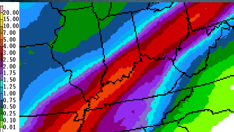
“Much of the Ohio River Valley has had over three inches of rain, some over four, and a few areas more than five,” he said. “That, in combination with what we’re expecting over the next couple of days, will send rivers up even further.”
The entire length of the Ohio River, from Pittsburgh to Cairo, Illinois, is under a flood warning. Some areas could see a crest of 10 or more feet above flood stage next week.
“At this point, within three days, we’re starting to see something that’s going to be very serious for all stretches of the Ohio River,” Sullivan said.
The areas forecast to see the most rain are the same that have seen it over the past few days, according to Sullivan.
“The heaviest precipitation will run from Central Arkansas, up the Ohio Valley, right up to Pittsburgh, over the next several days, with over four inches forecast for a good part of that area, especially Western and Central Kentucky,” he said.
Some of the other rivers that feed into the Ohio are also already above flood stage, or forecast to reach that level, including the Green, Rough, Rolling Fork, Kentucky and Licking Rivers.
Sullivan said the part of Kentucky that is east of Interstate-65 will fare better than areas to the west, including Eastern Kentucky, which experienced flooding between Feb. 9-12.
Another concern, especially west of a line from Owensboro to Bowling Green, is the potential for severe weather this weekend. The Storm Prediction Center has that part of Kentucky under a slight risk of severe weather on Saturday. Since the ground is so wet, it wouldn’t take as much wind as usual to cause trees to blow over.
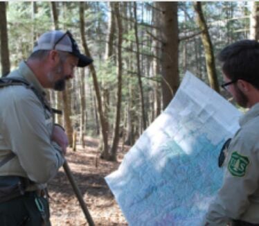
Meanwhile, Kentucky Emergency Management officials have requested the Federal Emergency Management Agency, or FEMA, to assess damage sustained on public roads, bridges, buildings and other public facilities during the floods.
Director Michael Dossett said: “We appreciate the timely response by our FEMA Region IV assessment teams in an effort to document the flooding damage caused to the infrastructure in multiple southeastern counties, as we look toward another severe rainfall event that may adversely affect our southwestern counties in the next several days.”
The assessments are being conducted to determine if damage levels are sufficient to request federal assistance. Seventeen counties are currently slated for assessments: Bell, Breathitt, Clay, Floyd, Harlan, Johnson, Knott, Knox, Lawrence, Lee, Leslie, Letcher, Magoffin, Metcalfe, Perry, Pike, and Whitley.
* * * * * *
Northern Kentucky
Northern Kentucky is under a flood watch, as the Ohio River has reached 56.2 feet and is expected to rise to 59.4 feet by Tuesday morning. The flood stage is 52 feet.
Several roads, Coney Island and Riverbend Music Theater are mostly underwater as are portions of Route 8.
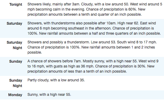
Rounds of heavy rainfall will continue through early Sunday morning.
Here is the extended forecast from the National Weather Service:
Will the Ohio rivers Cresting affect the rolling fork river… especially around colesburg
Hardin County is on the National Weather Service’s “hazardous weather outlook” list. Flood warning continues for Rolling Fork River near Boston until late Wednesday night. Flood stage is 35 feet and is right now at 44.5 feet and will continue to rise to 45.9 feet.