


By Tom Latek
Kentucky Today
It appears March will go out like a lion, as the National Weather Service is warning Kentuckians that severe weather is expected to develop in western Kentucky Friday evening, and move east across the state throughout the night.
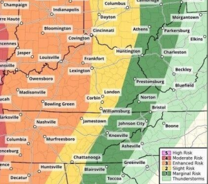
According to forecasters the greatest threat is in the west, where the Storm Prediction Center has issued a moderate risk for severe weather, although even the far east is under at least a marginal risk.
Gov. Andy Beshear even discussed the potential outbreak during a Friday press conference, saying the he had just spoken to meteorologists.
“The predictions are currently very concerning. Especially the Jackson Purchase area is in significant danger tonight. The word that meteorologists used was ‘probable,’ that we will see long-track violent tornadoes.”
He noted, “This is an area that was hit in December of 2021 by the unimaginable, and there is far too high of a probability that we will see that again tonight.”
Later on Friday, Beshear issued a state of emergency, saying it is the “worst forecast he has seen as Governor. I am declaring a state of emergency so that we can be prepared. We are taking this very seriously and we need you to take this seriously too.”
The National Weather Service added that while the west has the highest chance of seeing severe weather, with damaging winds and isolated tornadoes being the biggest threat, any severe potential farther east is dependent on the amount of available instability or “fuel”. As a result, they say confidence in that portion of the state remains low to medium.
The time of arrival of the severe weather is likely to be from 5 p.m. to 9 p.m. (CT), in the Purchase area, from 9 p.m. to 1 a.m. (ET) east of there to the I-65 corridor, from midnight to 4 a.m. (ET), east of there to the I-75 corridor, and 3-6 a.m., for eastern Kentucky.
In addition, non-thunderstorm winds will pick up out of the south and southwest Friday evening and continue into Saturday, with the strongest wind gusts likely occurring Saturday morning. Wind gusts of 40 to 50 mph will be possible during this timeframe, with isolated 55+ mph gusts. The strongest gusts will likely be across the Kentucky Bluegrass area, and forecasters say there is high confidence in the wind event.
Beshear says emergency officials have already been in contact with those still living in travel trailers due to the December 2021 tornado outbreak.
“We are going to be doing it again today. We are going to be asking each of them what their plans are, ensuring that they are not staying there tonight. It is not safe for them, or anyone in a mobile home tonight. Know the time it is likely to hit, have a plan. This is not a drill.”