


By Matt Becher
Boone County Government
If you look at the “Streets & Points of Interest Map” of Boone County, the landscape rolls up from the Ohio River for some miles before apparently falling off earth’s edge at the county’s eastern boundary. The exception is that part of the City of Walton leaking into Kenton County. Seen today mostly in digital form online or a smartphone app (and occasionally on a paper map), the dividing line between Boone and Kenton counties was once set in stone.
The boundary line was originally surveyed by Moses Scott in 1802 under order of the state legislature, to establish the line between Boone and parent county Campbell County. Kenton County was not carved from Campbell until 1840. While the Boone-Kenton line was resurveyed again by Boone County Surveyor Moses Rice in 1846, it would be another half-century before the two counties got serious about defining their territories.
The two counties teamed up in 1897 to resurvey their mutual boundary, probably in an effort to decide once and for all who got how much tax revenue from whom. The beginning point of the line was set as the low watermark on the north side of the Ohio River at a point 26 poles (429 feet) east of the confluence of Dry Creek (on the river’s south side).
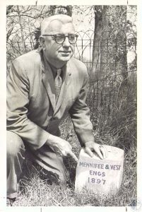
The other end at Grant County was at Bullock Pen Creek exactly 18.8577 miles to the south. The line was marked with 33 markers, set into the ground about 3,000 feet apart. They were made of Italian Carrara marble, measured about 1-foot square, and jutted a few inches above the ground surface. Each marker was engraved with the distance from the beginning in miles and fractions, the letters B and K for the counties, and the names “Mennifee” and “Vest” for the surveyors employed respectively by Kenton County and Boone County.
The 1897 project may have settled the boundary issue but the markers themselves were eventually forgotten, at least until long-time Boone County Surveyor Noel Walton took an interest in them in the early 1970s. It wasn’t until the early 1990s that the county retained him to resurvey the line and identify the remaining markers. The resulting Boone County Line Monument Relocation Project found just 10 of the original 33 markers intact. An additional 18 were confirmed destroyed, mostly by road construction, farming activities, or new construction. The others were never found. Over two decades later the fate of the 10 remaining intact 1897 county line markers found by Mr. Walton is unknown.
The Boone County Historic Preservation Review Board meets at 4 p.m. the second Thursday of most months. Meetings are open to the public.
For more information about Historic Preservation in Boone County please contact the Review Board at 859-334-2111 or mbecher@boonecountyky.org. The Review Board is online here.
This story appeared in the Your Boone County newsletter Nov. 24.