


By Tom Latek
Kentucky Today
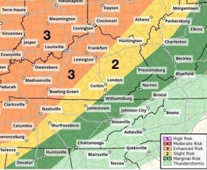
Most of Kentucky has been placed under an Enhanced Risk for severe weather on Wednesday by the National Weather Service, with damaging straight-line winds being the biggest threat, although there could be some brief tornadoes as well.
An enhanced risk is level 3 on the scale that goes from 1-5, with 5 being a high risk, according to Mike Kochasic with the NWS office in Louisville, with it being an all-day threat.
“From sunrise to even beyond sunset,” he said, “there will be chances for severe weather. There’s an atmosphere that is primed and ready. We will see isolated scattered threats for the first part of the day, but it’s a slow-moving system that is going to set up shop across Kentucky at some point, especially during the afternoon and evening hours.”
The main threat will be between 5-10 p.m. for western parts of Kentucky and continue east across the state, even into the overnight hours for eastern Kentucky, although the risk is expected to diminish the further east you are.
Kochasic notes confidence is still low in the forecast.
“There are different computer model runs saying different things. One, in particular, has the front coming in and stall across the central part of the state. If that happens, we could see some repeated rounds of storms that could bring some chances for flash flooding. Stay tuned for the latest forecasts as we continue to monitor the situation.”
He said they are expecting 1-2 inches of rain across the state, “But if the front stalls the way it could happen in some model runs, we could see 2+ inches of rain maybe even 3-4 inches of rain in a short duration of time in some spots.”
In addition to the severe threat, we could also see some high winds outside any storms, Kochasic stated.
“Southwest winds with gusts up to 45 miles per hour, means any east-west roads will have some high-profile vehicle trouble, like I-64 and some of the east-west Kentucky parkways. Driving conditions will be tough and any outdoor objects could be blowing around most of the day on Wednesday.”
A Wind Advisory is in effect from 4 a.m. to 4 p.m. (CT) in western Kentucky, and from 8 a.m. to 8 p.m. (ET) in the central part of the state.
“Folks should have multiple ways to receive weather warnings, with Wireless Emergency Alerts enabled on their mobile devices,“ he added, ”and make sure you know where your shelters are.”