


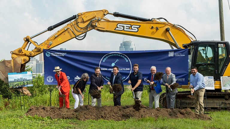


A powerful mapping tool designed to help communities protect greenspace and meet federal environmental requirements has a new name and major upgrades.
The Greenspace Environmental and Mitigation Mapper (GEMM) — developed by the Ohio-Kentucky-Indiana Regional Council of Governments (OKI) — now offers faster performance, new data and a modern design aimed at making environmental planning easier and more effective.
GEMM, formerly known as the Environmental Mitigation Suitability Modeler (EMSM), helps governments, conservation groups and developers identify the best locations for environmental mitigation. Mitigation is required of major construction projects to restore or preserve natural areas affected by the construction.
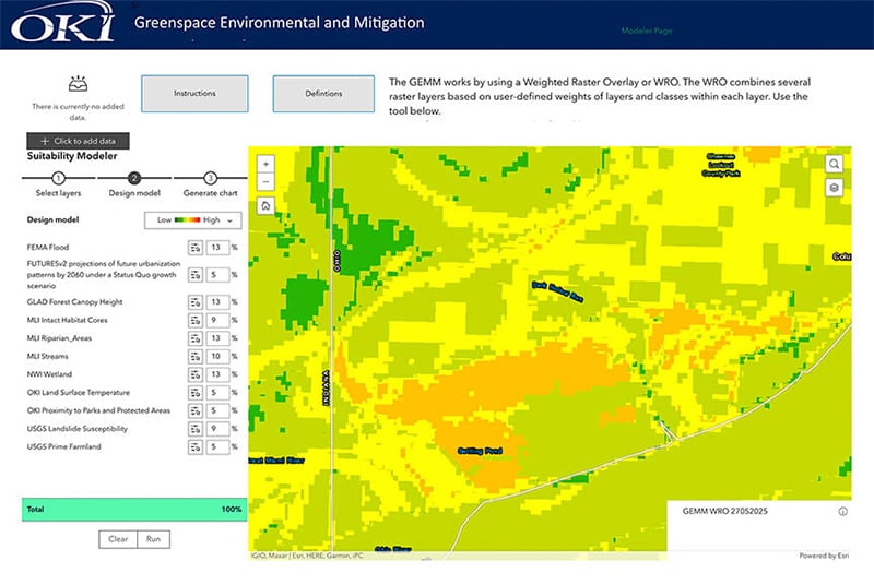
“This upgrade reflects what our communities told us they needed,” said Dr. Margaret Minzner, OKI senior environmental planner. “GEMM makes it easier to pinpoint where conservation work can make the biggest difference.”
Beyond identifying mitigation opportunities, GEMM also helps local governments and conservation partners proactively target the landscapes where conservation investments will have the greatest long‑term impact.
Boone County Conservation District (BCCDKY) and the Boone County Planning Commission (BCPC) partnered on a high‑level environmental study to support the county’s Comprehensive Development Plan. Using OKI’s environmental mitigation tool, the study mapped Boone County’s most sensitive natural areas and key ecological resources.

“As Boone County continues to grow and develop, it is important to inventory and learn more about our county’s most pristine and unique natural resource communities,” said Tyler Rankin, forest health specialist with the BCCDKY. “These areas promote the health and wellbeing of our citizens by providing clean air, improving water quality, creating opportunities for recreation, and protecting the biodiversity and habitat for many unique species of plants and wildlife.”
This focus on natural resources comes as Boone County continues to experience significant growth. The county grew from 135,994 residents in 2020 to 144,135 in 2024, making it the fastest‑growing county in the OKI Region (U.S. Census Bureau Population Estimates)
GEMM’s contribution to the study “showed us that publicly available scientific data can reliably identify priority conservation areas within Boone County that should be considered in future planning decisions,” Rankin said. “Its flexible modeling approach allows parameters to be updated as new data becomes available, ensuring the county can continually refine its understanding of sensitive landscapes over time.”
“The revamped tool includes major improvements that make it smarter and more user‑friendly,” Minzner said.
Even before the upgrade, the tool aided local organizations in directing environmental investments:
• Boone County Forest Study: A Miami University researcher used the model to identify habitats important for bat populations – which helped guide local forest management decisions in the county.
• Taking Root Urban Forestry Initiative: By analyzing tree canopy and air‑quality data, the group pinpointed Cincinnati neighborhoods most in need of trees, which helped secure a $10,000 Duke Energy Foundation grant to plant them.
The idea for the tool was sparked by Boone County Judge/Executive Gary Moore, a past president and current member of OKI’s Board of Directors. During a public meeting, Moore noted that the OKI region was missing opportunities to retain required compensation being paid by developers when projects negatively affect surrounding natural resources.

Moore was referring to mitigation banking — a system that offsets ecological losses from development by funding the preservation or restoration of other sites. Mitigation banks typically focus on wetlands and streams, while conservation banks protect habitats for endangered species.
“With some of our larger new development projects in Boone County, we’ve witnessed large environmental investments required through mitigation being sent to other regions instead of mitigating the impacted watershed here.” Moore recalled. “Having a tool to quickly evaluate and assess appropriate environmental improvements here in our region will allow more of these investments to remain here, improving our residents’ quality of life.”
The tool’s usefulness has attracted interest well beyond the Cincinnati region.
Minzner and OKI staff have been invited to present GEMM at national conferences and recently demonstrated it at the request of the Federal Highway Administration to agencies including the U.S. Army Corps of Engineers, EPA, U.S. Fish and Wildlife Service, and National Park Service.
“I believe GEMM’s potential is limitless,” Minzner said. “As communities face the realities of climate change, this tool gives them a clearer path to smarter land‑use and conservation decisions.”
Ohio-Kentucky-Indiana Regional Council of Governments